We're back to old maps again today.
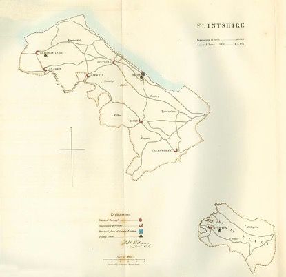
Maps tells us lots of things and maps are created for a purpose. This is the Boundary Commission Report Map for Flintshire dated 1832 – the year of The Great Reform Act. Those of you studying history at a higher level in school and college will know a bit about this and how important the act became to change the political landscape of Britain.
Flintshire was then a unique place in Britain, for the county was split into two parts – 'Flintshire Main County' and 'The Maelor Saesneg' part of Flintshire, centred on Bangor-on-Dee. Read more about the history of why
here.
You will see from the map that in 1832 the population of Flintshire was 60,100 (of which only 1359 people had a vote - see more on Flint Boroughs
here – the population is now well in excess of 160,000 (with fortunately the majority of adults being franchised), although boundary changes in the 1990s have seen the loss of towns such as Rhuddlan, Prestatyn, Rhyl, Bodelwyddan and St.Asaph from 'old Flintshire' to Denbighshire.
Notice too that the Principal Borough of the county is placed as Flint, with Mold (now the County Town) being a Contributory Borough. Talk to old Flintonians and they believe their town should still be the county town, as Mold is the young pretender to the county town of Flintshire.
Incidentally, Earl Grey (Leader of the Whigs), as in the tasty tea, won the election in 1832 and continued as Prime Minister.
So to modern times...
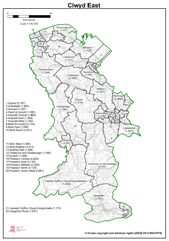
Below are the proposed alterations to boundaries for the area I live in, which come into effect from 2024, renamed as Clwyd East - for us North Walians, this means that the old 'nine constituencies' are slimmed down to seven - apparently to do with populations which are within 5% of an electoral quota mean of 73,393. This just shows how, through history, right up to modern times, maps have been used to carve up the land for whatever purpose the map maker deems necessary. Cynical old me, in times gone by, might have suspected some ulterior motive or gerrymandering of votes going on but, na, they wouldn't do that...
Full explanation of the changes in Wales
here.
None of this alters currently alters 'Flintshire' as a county with its own County Council, although more and more, it is a county in name only - the next question being, when will Flintshire as a council area cease to exist! Time will tell.
#flintshire #reformact1832 #flint #parliament #boundarychanges #history